Back

Why Systems Tool Kit? Part I

  • Oct 18, 2012
  • Tech Tip
According to Merriam-Webster, a system is “a regularly interacting or interdependent group of items forming a unified whole.” STK is capable of modeling and evaluating systems and is, in itself, a system. So what kinds of systems does STK model and evaluate? From super-scientific uses like modeling the orbit (and eventual touchdown) and coverage around a 33-km long potato-shaped asteroid to out-of-the-box ones such as tracking elephants in Malaysia or determining the position covariance of boreholes for oil rigs, our users have always amazed us with their applications of “Satellite Tool Kit.” But the name hasn’t fit the use cases for some time. Would you use something called Satellite Tool Kit for UAV mission planning? Operational multi-INT data fusion for situational awareness? Logistics tracking and range safety on DoD test ranges? Missile threat modeling? Probably not. However, STK has been used for many years for these applications, plus, the standard space stuff like GPS performance modeling, launch window analysis, space rendezvous operations, laser clearing, RF interference mitigation studies, conjunction analysis, link budget analysis and so on. To be honest, we could have just changed the name on any of one of our past releases and called it a day – because our users are the ones who have transformed the product from Satellite Tool Kit to Systems Tool Kit. Now let’s take a deeper look at my second point, STK is in itself a system and we have made a concerted effort to make it more broadly applicable with our upcoming v10 release. So how did we do that?
  • 3D for everyone
  • Data availability
  • Easier to use
  • Make STK look and behave the way you want to
  • A system of value-added products
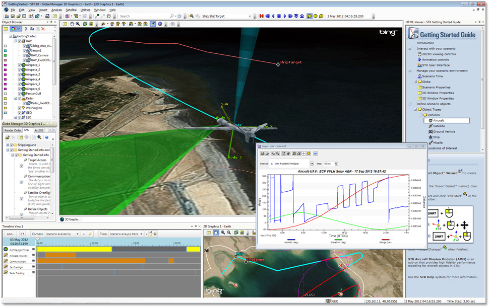
3D for everyone I talked about this before so I’m not going to rehash it in-depth again – basically we realize everyone loves 3D and everyone expects 3D – and ours is simply more powerful from an engineering standpoint than the other players, so now you can have it. Data availability STK originally had a “create your data” workflow as the default (pretty much the only choice other than external or real-time data) which was great and probably preferable to our space customers. But since our system is supposed to be broadly applicable, we took incremental steps to make it that way. Over the last 10 years, we had already started with things like reading TLE catalogs and creating Walker constellations, then we evolved to auto-updating the TLE catalog and providing the GPS almanac. Although very powerful and robustly implemented, all of that streamlining over the years primarily benefited the space community. Other users might not even realize that they can go to the TLE database and simply search for “imaging” satellites because they did not even know what the TLE database was and that the TLE database was a good place to look. One of our goals for STK 10 was to start converting our community from a “create your data” mentality to a “select your data” mentality. For years we have been collecting facility data, associated az/el masks and historical satellite data (TLEs). With STK 10 we are moving that to the forefront. For starters we now have a master search tool bar which allows you to free form type the satellite, street address or place of interest or facility name, and STK will go out and search our licensed geocoder and our cloud-based data server for all the matches. Simply select your match and voila – it’s in STK and ready for action. This is just the initial release of our search capability and we already have test versions of the software that includes search or conversion to area targets and aircraft performance models. Also targeted for the next interim release, the search bar will include your local databases – which means one location to find key STK data online or offline. I mentioned our cloud-based server, which is our implementation of the STK Data Federate hosted as a service to our users. Not only can you search and retrieve standard STK objects such as satellite, facilities, and aircraft; but you can download scenarios of standard space systems that are ready to be customized for your particular analysis. Don’t know much about satellites, but need to do RF analysis on the Intelsat network? No problem. Just download the Intelsat scenario and you’ll get all of the satellite and ground stations ready to go in an STK scenario. Once you tailor the scenario to your needs, you can simply save the scenario (with version control) back on our server with your own private account. It’s not just STK object data that we’ve made more available, we also have a licensing agreement with Microsoft that provides you unlimited use of the Bing Maps imagery server and geocoder. You can also drag and drop KML files or GIS map data right into our globe manager, and we plan to expand the availability of data sources moving forward with streaming terrain. Easier to use We have always tried to appeal to more than just the “rocket scientists,” but admittedly our users are working complex problems that have often led us down the path of creating complex GUIs and workflows. We’ve made some great strides in v10 and plan to continue with the theme in future releases. Most visible in STK 10 will be our new Timeline View. With the new ability to create and manipulate time intervals (Time tool within Analysis Workbench), we needed to give the operator a global view of the system, and a spot where you can “see” all of the interdependencies both graphically and visually. Other usability enhancements include an overhaul of the logical flow of the menu (targeting the easiest ways to create and manage objects), a new getting started guide that highlights key functionality with quick how-to videos and new controls on the object browser for key functions like on/off and color selection. What’s next moving forward? An overhaul of the workflows for constraints, comm analysis and coverage analysis. Make STK look and behave the way you want it to A point that often gets lost about the free version of STK, and the capability extends into each additional module, is how open and customizable STK is. Make STK look and behave the way you want to! With the free version alone you have all this power …
  • Importing and exporting data from common tools (MATLAB, Esri and KML)
  • Build an HTML interface for a common or simplified workflow
  • Build custom user interface plugins
  • Create a custom application or “in-process” automation of STK with the STK Engine API via TCP/IP protocol or Microsoft COM interface
I won’t go into all of the details here – but the takeaway is, if you don’t quite like STK the way it is right out of the box, it probably is a pretty strong start to what you need and you have the ability to tweak the final touches. OK, this was a lot for me write, and probably a lot for you to ingest. So please stay tuned for Part II of this blog, where I’ll get into the last point of “why STK is a system” – a system of value-added modules.
Author